MAP CONTROLS: Use slider or mousewheel to zoom, and hold down left mouse button
to drag.
KEY: Location markers are coloured from Green meaning exact to Red meaning
gone or unknown (details here)
|
Location Category ID:
|
820
|
|
Added to Database:
|
25 April 2011
|
|
Last Edited:
|
25 April 2011
|
|
Address: |
Küglerweg, 33104 Paderborn
|
|
Telephone: |
|
|
Email: |
|
|
Opening Times: |
|
|
Official Website: |
|
|
Other Links: |
Bing Bird’s Eye View
Wikipedia – Sennelager
BAOR Locations
|
|
Latitude, Longitude: |
51.77798395
,
8.73108588
|
|
Location Accuracy: |
7
|
|
Tanks Previously Here: |
|
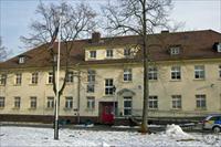
Sennelager is a village in Germany that forms part of the City of Paderborn. It contains a number of British Army barracks, and is located on the edge of the Sennelager Training Area (qv). Normandy Barracks is a large British Army complex that contains a number of individual unit areas including Antwerp barracks.
|
Location Images - Photographs and NavPix (click to expand or browse)
2010
|
| | | |  | | | | |
1: Part of Normandy Barracks
Taken: 2010 (Estimated)
Contributor: Crown Copyright
Location Photo ID: 454
Added: 25 April 2011
Views: 318
Has Priority: 0
|
| | | | | |
|
|